
Virginian Research
Longest Curve and Pepper/Price/Prices Station
A thread on the Virginian discussion list diverged into several different topics, all of which are interesting in their own right.
The Montgomery County GIS site has aerial images (once zoomed in far enough) that have incredible detail. Several views help illustrate what has been discussed in the threads. Click on a thumbnail to see a large image.
In and About Town
What is said to be the longest curve in this county, and probably any other country, is on the Tidewater in Montgomery county, Va. The road makes this curve at what is known at the horse shoe bend on New River, and it reaches from two miles west of Toms Creek to Prime, a distance of five miles and a half.
Bluefield Daily Telegraph
August 8, 1907
[The mouth of Toms Creek is at Whitethorne (MP 287.7) so the west end of the curve according to the article would be MP 289.7, which is about across the river from Cowan on the N&W. Five miles and a half east of that point would be MP 284.2, which is present-day Pepper, where it appears there used to be the junction of a spur leading into the Radford Arsenal. Could Pepper have been known as Prime?]
Gordon Hamilton
Sun, Jun 29, 2008
Just a guess, but with some investigation:
the curve is the section of railroad along the north side of the river horseshoe starts at the entrance to the horseshoe opposite N&W Pepper Tunnel ends at Prices Station Rd, the old road going downhill to the Arsenal
I have to assume that Prime (not found in the GNIS database) should be Price (as listed on the timetable in Reid’s book). The location of Price’s Station, according to the GNIS database, is at the crossing of VGN and Price’s Station Rd (as close as I can measure with my meager tools), matches the distance to Price/Prime in the article.
Gordon: Is that where you found the old spur? Where did you see that detail?
That’s close enough for me until someone finds greater detail. Question is why that is considered a continuous curve when there seem to be jinks along the way, thus breaking the continuity of the curve.
Craig Close
Balimer, Merlan
OK: Far West Catonsville
OR: Greater Oella
Sun, Jun 29, 2008
OK, working though some of this backwards to establish a few landmarks (here in my backyard), the New River does kink a bit through this area. The river is flowing roughly north as it passes under the VA 114 (Peppers Ferry) bridge. The N&W is on the east bank here, headed timetable west. Where the line crosses the river to then enter Cowan Tunnel, the New River turns east to start the horseshoe bend as it flows through the Radford Arsenal.
About where the river starts to bend north is where the Virginian leaves the river on its way to turn east to follow Slate Branch up to Merrimac. The track is well above the river here, on a steady 0.60% climb from Whitethorne. The line goes through a tunnel here, variously known as Pepper Tunnel or New River Tunnel. It is at about MP 283.3 and is crossed by “new" Prices Fork Road. It is at the west portal of the tunnel where the branch took off to the right (while looking east), dropping down into the Radford Arsenal. Remnants of the grade can still be seen here.
Continuing timetable west on the VGN, the line is in a continuous left-hand curve for about a half-mile to MP 284, labeled Pepper on my track chart. There is/was a house track here, at the former station site. Price Station Road goes under the tracks here via a pretty substantial tunnel and ends at a now-closed gate into the Arsenal. At one time, this road was open to the public and was the route between Blacksburg and Radford. I believe it was closed as a through route during the Korean War. “New" Prices Fork Road finally replaced this road in the late ’70s.
The track continues north (timetable west) on a tangent along the top of the horseshoe bend, then curves left as the river bends to the west. The line follows the river, dropping down to Whitethorne, which is at about the middle of that leg of the river horseshoe.
At MP 289, a long right-hand curve starts (almost a haff mile at 5 degrees) to bend the line along the river as it turns north again. It is just before where this curve starts that the N&W pops out of the west end of Cowan Tunnel across the river. The VGN then wiggles through a series of lefthand and righthand curves on its way to McCoy and on up the river.
Now how this translates into the longest curve in the county is beyond me, unless one just looks at a big map and extrapolates from there. I would think that the real horseshoe curve wrapping around Ellett to lose elevation between Yellow Sulphur and Fagg would be a bigger and longer curve than the one on the river.
Bruce in Blacksburg
Sun, Jun 29, 2008
The name was changed from Price to Pepper. I have no information on a location named Prime. Note the spelling is close. Could be a typo.
Jim Blackstock
Mon, Jun 30, 2008
One clarification: Price’s Station Rd was open to the public thru the Arsenal, early morning ’til 11 PM or midnight, at least until the mid-60s.
Craig Close
Balimer, Merlan
OK: Far West Catonsville
OR: Greater Oella
Mon, Jun 30, 2008
In a 1924 timetable Price is located at MP 284.2.
Jeff Sanders
July 2, 2008
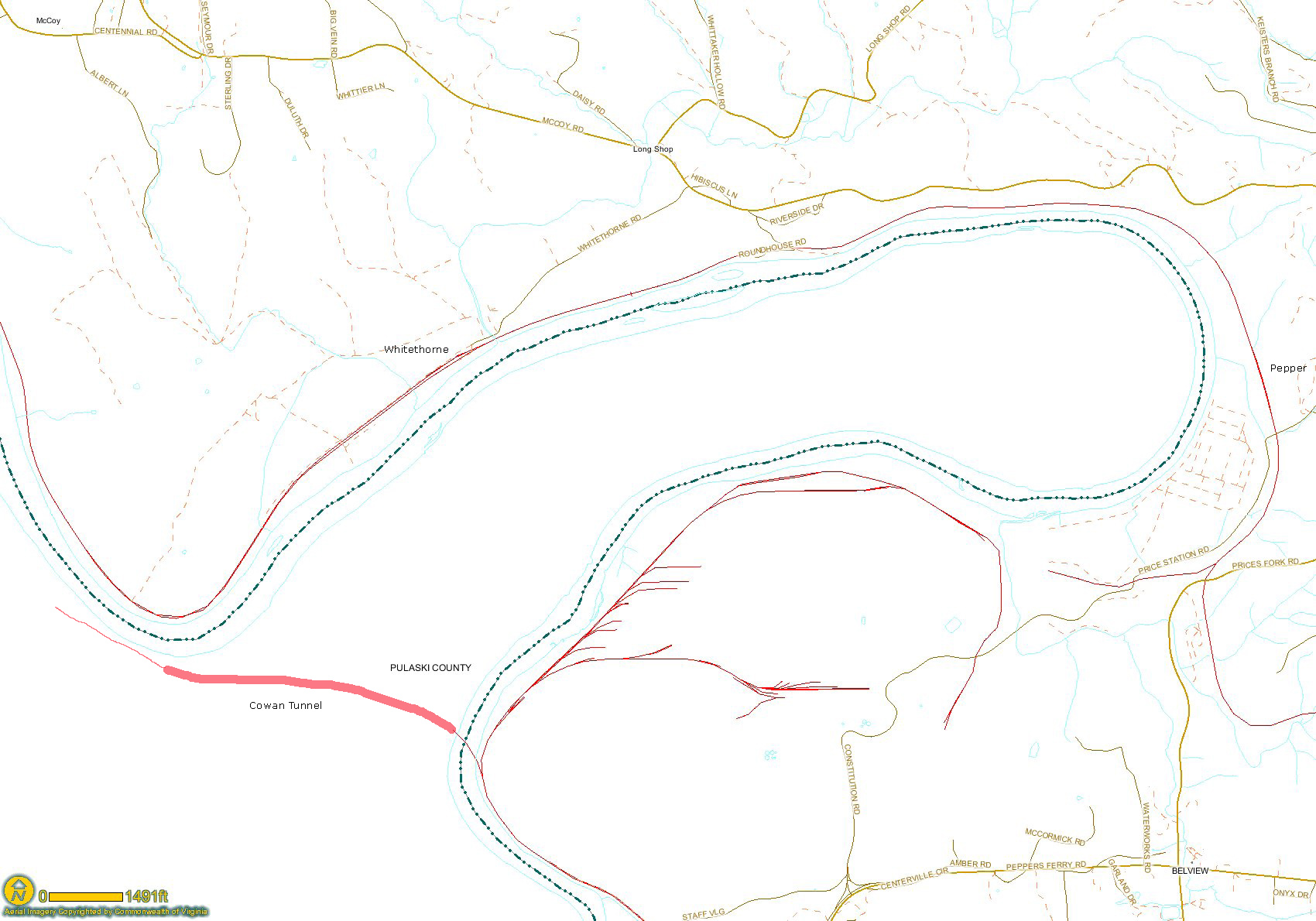
Image showing horseshoe bend in New River
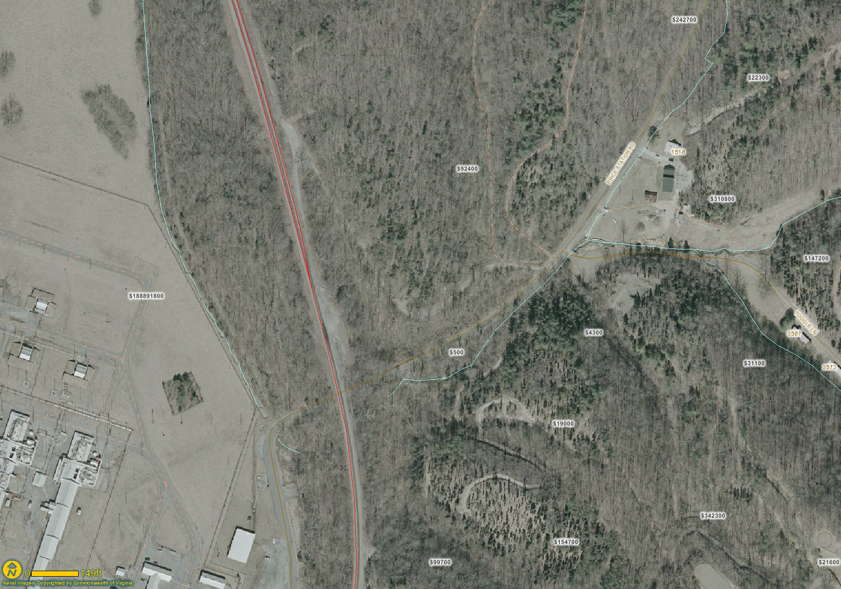
Aerial image showing station site. The red line is the Virginian track and the yellow lines are roads. Note Price Station Road as it approaches the rail line. There is a curving lane to the right that leads up to the station site. The tracks cross the road on a substatial fill.
Pertinent track charts